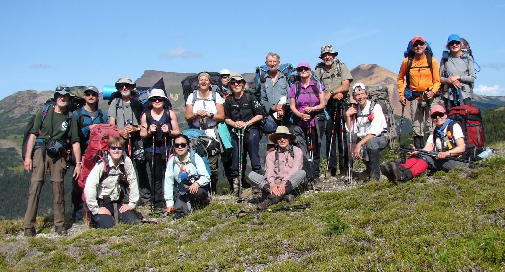
The Caledonia Ramblers latest weeklong backpack into the Rainbow Range of southern Tweedsmuir Provincial Park turned out to be a wonderful trip, with none of the fires and smoke of the past two summers. Several of the 17 participants had been in the area before, but only the trip leader, Dave King and participant, Hilary Crowley had previously hiked the whole route, so there was something new for nearly everyone. According to Hilary, the average age of participants was 60, and ranged from 27 to 77.
We left Prince George on August 10th, 2019 and rendezvoused later that morning in Williams Lake, before heading west for 333 kilometres on the mostly repaved highway to Anahim Lake. Beyond that, the last 40 kilometres to the Heckman Pass trailhead remain unpaved, but that section is all first-class gravel. We stopped just before Anahim Lake to camp overnight at the Fishtrap Recreation Site just past Nimpo Lake on the Dean River, while some drove into Anahim Lake for supper.
By 9:30 a.m. the next morning we had assembled in Heckman Pass and were soon on the trail to the Rainbow Range. Everyone had moderately heavy packs with a week of food plus all the clothes and gear needed for a northern mountain trip, this being no place for ultra-lightweight backpacking. The trail began in a forest that had burned some ten years earlier, then slowly climbed towards the subalpine as we all got accustomed to our packs.
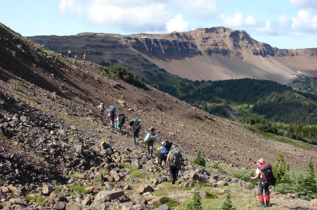
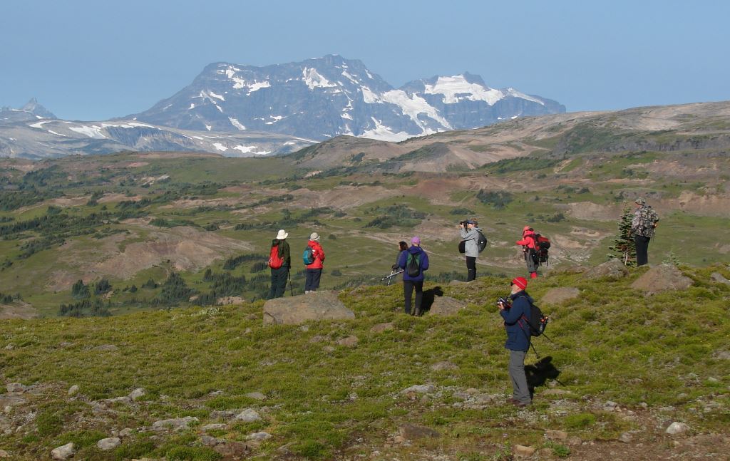
After hiking eight kilometres, we reached tree line at McCauley Lake and stopped for lunch before continuing north into mostly alpine terrain towards de Macedo Lakes. There, we planned to establish camp for the first two nights. The route was fairly easy going through meadows, with very little rocky ground. Disconcertingly, and not too far from our destination for the day, we came across fresh grizzly tracks and a huge amount of bear scat at an obvious bedding site. We also got our first look at the colourful Rainbow Range.
There are several lakes near where we proposed to camp, and it took us a while to decide on a spot that had good water, shelter from wind, space for 12 tents, and set well back from the grizzly movement corridor. On a club trip led by former member Doug Perkins in the 1990s, they had camped a few hundred metres away in the middle of the pass and had the alarming experience in the evening of having several grizzly bears walk right into their camp, a possibility highlighted for us by the nearby bear sign.
Our first camp turned out to be delightful, with no furry guests and a pristine creek meandering around the tents to afford individual access to water. After settling in, we climbed the ridge immediately north of the camp for an evening view of the Rainbows.
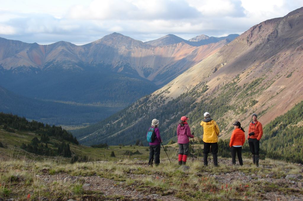
The morning of August 12th was pleasant and we were all were up at first light. By 8 a.m. some were already heading for the high peak to the east, and soon everyone else followed. Half of the group climbed the peak, while others began a slow amble northward along the ridge. There were nice views in all directions, but especially of the Rainbow Range to the west and north. We spotted mountain goat and caribou tracks, but saw no actual animals. The alpine flowers were nice, but well past their best for the season; and we noted isolated white bark pine trees throughout our trip both above and below tree line.
After regrouping and eating lunch on the northernmost peak of the ridge, we headed back to camp, whence several diehards promptly headed up the hill south of camp that is dominated by two volcanic plugs. On an earlier trip in the 1980s we had found some obsidian there, as we did later on this trip below Mount Mackenzie. In the late afternoon, eight horses and seven riders rode past our camp, traveling from Beef Creek towards the Heckman Pass trailhead.
On August 13th (day-3) we broke camp and, shouldering already lighter packs, we headed west towards Crystal Lake. By mid-afternoon, following a sharp rain shower, we reached the Crystal Lake Trail where we met three horses cresting the ridge ahead of us. The Park Ranger's wife and daughter and a third rider had been working on the Mackenzie Valley cabin and were heading out towards Heckman Pass.
The weather had been threatening, and soon after this encounter we were hit by a fierce electrical storm with heavy hail and rain. Heads down, and succumbing to a herd instinct under nearly continuous crashes of thunder, we soldiered on to meadows half a kilometre south of Crystal Lake, where we finally held up to let the storm pass. Looking around after the storm, we decided to camp where we were as there was good water and some shelter. Then, someone spotted what we first thought was a caribou, half a kilometre back along the slope that we had crossed in the storm. It turned out to be a member of our party who, to our chagrin, no one had even realized was missing. He had hunkered down in some trees and then lost contact with the rest of the party. A good lesson for all of us.
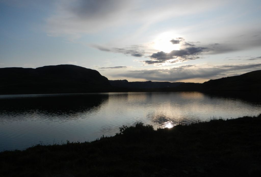
That evening several people wandered up to Crystal Lake just in time to see it lit by a fine sunset. Although it is a designated camping area with an outhouse, Crystal Lake is quite exposed, and we were glad to be set up lower down.
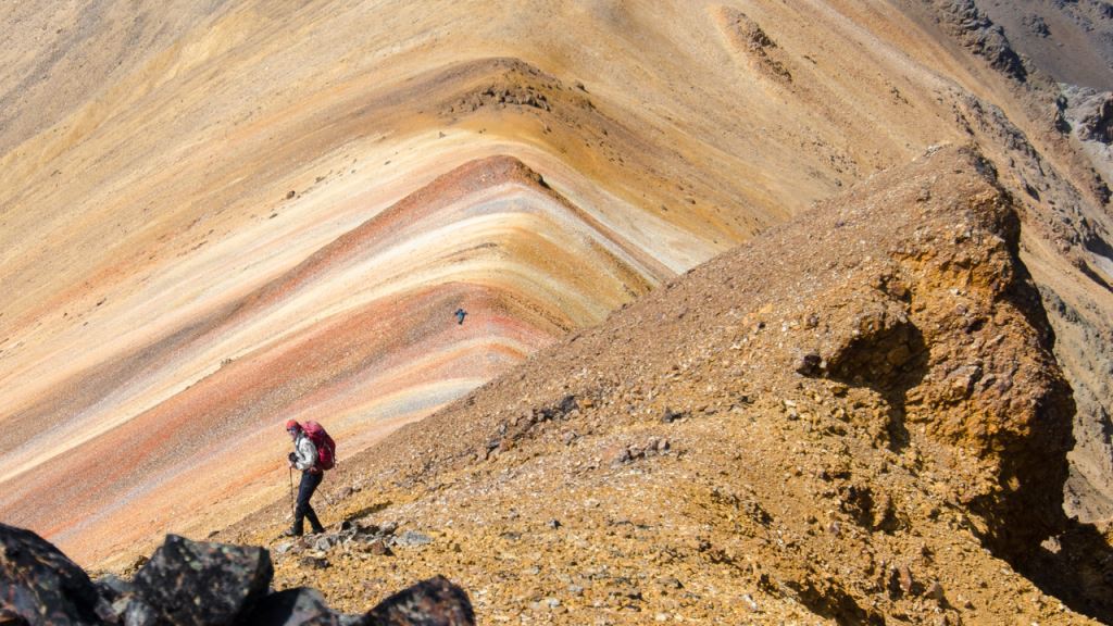
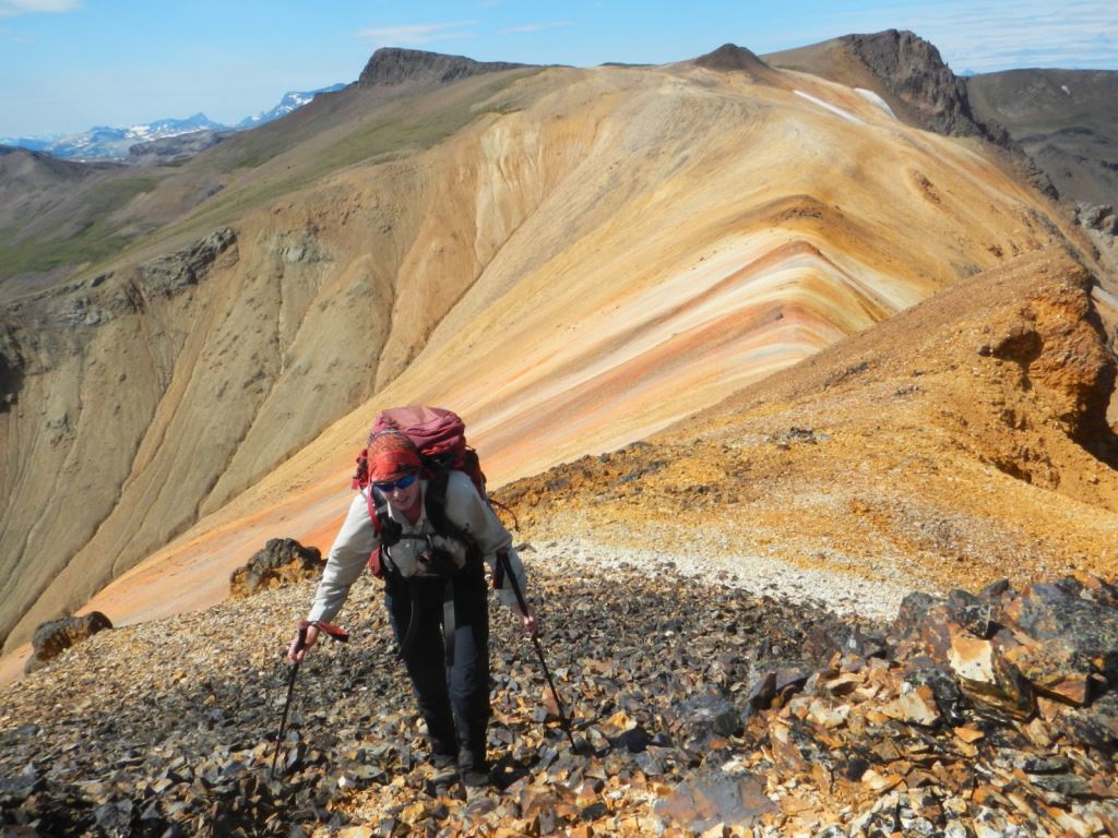
August 14th saw us continue our hike southwestward around several slopes until we hit the Tweedsmuir Trail, with good views of Mount Mackenzie and its colourful spur ridge. We set up camp in an area shown on one map as ‘The Terraces,’ where there was plenty of sign of old horse camping. Again we stayed two nights.
We arrived at midday, and after lunch some hiked to the ridges southeast and above camp, while others explored the immediate area and/or bathed in one of the many tarns. On the ridgetop east of camp, we found an old survey marker and a nearby fire pit suggesting that the surveyors (probably in the early to mid-20th Century) had spent some time up there, likely waiting for clearing sight lines in order to tie into other survey points.
We were impressed by the large number of small lakes and ponds everywhere in the alpine meadows. We continued to see caribou tracks in many places, as well as wolf and grizzly tracks and a few goat tracks, but still nary a large animal. We did spot occasional hoary marmots, a few ptarmigan, and two vacated nests with hatched eggs. On three previous trips to the area I didn’t see much wildlife either, except for a couple of goats, a grizzly and two or three caribou. With our large numbers, this was not surprising, but the abundant sign everywhere indicated that the area is rich in wildlife.
Late in the afternoon a Park Ranger, Steven, with one companion showed up on their horses. They had been working on the cabin and were headed for Octopus Lake. They told us that the trails in this area had essentially been closed the past two years due to the forest fires and they were headed out to Heckman Pass and would be clearing deadfall with the chainsaw that they had with them. What a stroke of luck this turned out to be for us.
On August 15th (day-5) we day hiked over to Mackenzie Pass and Mount Mackenzie. It was a fine clear day with the Coast Mountains visible on the south side of the Bella Coola Valley, sharp and clear. Outward bound in the morning, we walked along the ridges west of camp, with the more ardent climbers in the party going over the top, and most going around the southerly side to the Nuxalk-Carrier Grease Trail.
On the older 1:50,000 topo maps that we were carrying, the Mackenzie Pass is incorrectly shown more than a kilometre southeast of where it actually is. The Nuxalk-Carrier Grease Trail (Alexander Mackenzie Heritage Trail) is now also part of the National Hiking Trail. Several of the old posts marking the historic trail had fallen down and we reset them. Clearly the trail has not been used in a long time, likely due to the forest fires and closures. It would be a tough route to follow today, especially in poor visibility.
Eight people scrambled to the summit of Mount Mackenzie and then hiked a kilometre or so northeast along a spectacular ridge dominated by rainbow-coloured rock and scree. The day continued clear and beautiful and they saw the red roof of the cabin in Mackenzie Valley, and at last they spotted a dozen mountain goats on a ridge southeast of Mount Mackenzie. This was the only big game seen on the entire trip.
In returning to camp both parties took an alternate path down into the valley on the north side of our earlier ridge route. It’s an easier route to or from Mackenzie Pass and Mount Mackenzie from our campsite, but lacks the views that we had in the morning.
On August 16th, our plan was to hike down the Tweedsmuir Trail to Octopus Lake, and then take the Octopus Trail to Young's Creek and spend our last night there. However, with another fine morning we were packed up and on the trail by 8:30 a.m. We had more nice views of the Coast Mountains as we gradually descended into the forest. The Park Ranger and his companion had cut out all the deadfall as promised, making it a relatively easy and fast route. With a good trail, lighter packs and a fit group, we arrived at Young's Creek by early afternoon, and by majority vote we agreed to hike out the last eight kilometres to the Heckman trailhead that day.
From there, we were all cast to the winds. Some drove the full 615 kilometres back to Prince George that night, while others camped at various sites along Highway 20; two stayed for work in Anahim Lake, and three braved the infamous ‘Hill’ down to Bella Coola.
The Rainbow Range offers a spectacularly varied setting, with relatively easy mountain hiking, well away from the crowds, and easily accessible to two-wheel drive cars. Apart from the three equine parties that we met briefly (each providing a useful information exchange), we did not see another human in six days until the last few kilometres when we met a couple from Germany who were just starting out. They likely had the entire area to themselves. For more information and maps, see BC Parks website for South Tweedsmuir Provincial Park.
- Dave King
Note: This story was also published in Cloudburst.
Footnote: In the steps of Sir Alexander Mackenzie
On Monday July 22, 1793, Alexander Mackenzie[i] became the first known person to cross the North American continent north of Mexico from sea (to sea) to sea, reaching the Pacific Ocean at the Mackenzie Rock in the Dean Channel. He just missed meeting Captain Vancouver in Bella Coola by a few weeks, and he beat Lewis and Clark’s mere sea to sea journey by more than 12 years.
He had passed through what is now Prince George on Wednesday, June 19, 1793, but it was a foggy morning and, remarkably, he missed the Nechako River confluence, which would have been exactly what he was looking for, namely a large river from the west. Had he seen the Nechako, it is likely that he would have proceeded west up that river and there would be no Mackenzie Pass in south Tweedsmuir today.
Instead, he proceeded south down the Fraser until, warned by natives about obstacles ahead (notably the Fraser Canyon) he turned back and proceeded some 400 kilometres overland from the Fraser River via Poncho (now Punchaw) Lake just south of present day Prince George. He was guided by natives over their ancient grease trail. Mackenzie crossed the mountain pass that now bears his name on Wednesday July 17, 1793, where shortly afterwards his party encountered a fierce hail storm similar to the one that we experienced near Crystal Lake.
It is interesting to note that we staged our trip from a campsite on the headwaters of the famous Dean River, while Mackenzie ended his journey on a defensible rock in the Dean Channel.
[i] ‘Journals and Letters of Sir Alexander Mackenzie’ published in 1970 by Cambridge University Press; containing Mackenzie’s original 1801 version titled ‘Voyages From Montreal, On The River St. Laurence, Through The Continent Of North America, To The Frozen And Pacific Oceans.’